
Faisal Town Phase 2 Map & Location
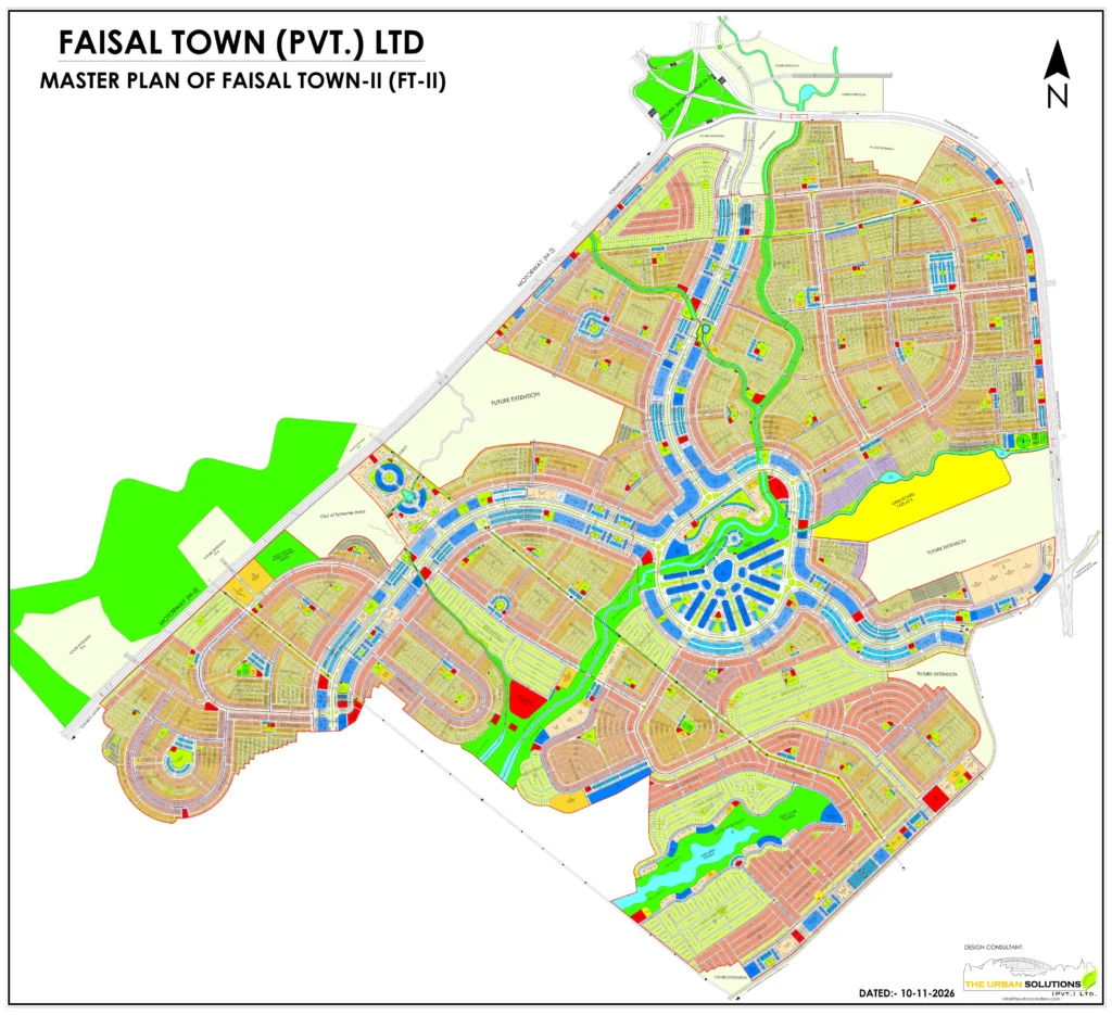
Tap or click the map to zoom in · Get the Map PDF with plot numbers
This is the Faisal Town Phase 2 map with plot numbers, as shared by FaisalTown Group. Zoom in to find your sector. For the full map PDF with plot numbers, enter your name and WhatsApp number below:
- Location: Thalian Interchange, Lahore–Islamabad Motorway (M-2)
- Bordered by: Rawalpindi Ring Road and Chakri Road
- Airport: Islamabad International Airport is a short drive away
Faisal Town Phase 2 Map with Plot Numbers
The map at the top of this page shows Faisal Town Phase 2 with its sectors, plot numbers, internal roads, parks and commercial areas. To find a plot, first locate its sector, then zoom in on that sector to read the plot numbers.
Buyers often call sectors “blocks”, for example O Block or P Block. On the map they are marked as sectors, such as Sector O and Sector P.
Maps and master plans are as shared by FaisalTown Group and may be updated. Always confirm a plot number before booking.
Get the HD Map & Site Location on WhatsApp
Cannot read a plot number, or want to see where your plot is on the ground? Share your WhatsApp number and we will send you:
- The HD Faisal Town Phase 2 map with plot numbers
- The Site Office location pin and directions
- Help planning a site visit, even from abroad
Get Map & Site Location Details
Share your WhatsApp number and we will send you the HD map, the Site Office location pin and directions.
Faisal Town Phase 2 Location on Google Map
If you are planning to visit Faisal Town Phase 2, the Google Map below shows the location of the Faisal Town Phase 2 Site Office. Use it to check the route from where you are before you travel.
To navigate, open the location in Google Maps and tap Directions. Google Maps will show the best route from your current location.
Where Is Faisal Town Phase 2 Located?
Faisal Town Phase 2, also called Faisal Town 2 or FT2, is in the Thalian area of Rawalpindi, in the Twin Cities region. It directly adjoins Thalian Interchange on the Lahore–Islamabad Motorway (M-2) and stretches along the motorway towards Lahore. Islamabad International Airport is a short drive away.
The housing society is bordered by three major roads:
- Lahore–Islamabad Motorway (M-2) along the north-western side, with Thalian Interchange at the northern corner of the society
- Rawalpindi Ring Road along the northern edge and down the eastern side, signposted towards GT Road (N-5) and the Lahore–Islamabad Motorway (M-2)
- Chakri Road on the eastern side, where the plan marks the Chakri Road Interchange of the Ring Road next to Sector A, with Chakri Road continuing towards Rawalpindi
The plan also shows two proposed connections from the Ring Road to the 350-foot main boulevards – one on the Thalian side in the north and one near the Chakri Road Interchange in the east; final entry points will be confirmed by the developer. Inside the society, as per the current master plan, wide boulevards of up to 350 feet link the sectors to these access points, meeting around a large central circle at the Central Business District. Residential streets are mostly around 40 feet wide. Road positions are read from the master plan available at the time of writing and may be revised by the developer.
The Motorway and the Ring Road meet at Thalian Interchange, which adjoins Faisal Town Phase 2. Together these roads link the community with Islamabad, Rawalpindi, Lahore and the surrounding areas.
Faisal Town Phase 2 Master Plan & Map PDF
The Faisal Town Phase 2 master plan gives an overall view of the community layout, including its internal road network, the planned sectors and areas, and the major roads around it. It also shows how the community sits along the Lahore–Islamabad Motorway (M-2) and the Rawalpindi Ring Road.
Download the map PDF to view the full master plan in high detail and keep it on your phone for your site visit.
How to Reach Faisal Town Phase 2 | Directions
From Thalian Interchange
Thalian Interchange adjoins Faisal Town Phase 2 and is the most direct access point. It is where the Lahore–Islamabad Motorway (M-2) and the Rawalpindi Ring Road meet.
From Lahore–Islamabad Motorway (M-2)
Faisal Town Phase 2 stretches along the Lahore–Islamabad Motorway (M-2). Travellers coming from Lahore or Islamabad take the Thalian Interchange exit to reach the community.
From Rawalpindi Ring Road
The Ring Road borders the community and meets the motorway at Thalian Interchange, linking Faisal Town Phase 2 with Rawalpindi and the surrounding areas.
From Chakri Interchange
Chakri Interchange on the Rawalpindi Ring Road gives another approach to Faisal Town Phase 2 from the Chakri side of the road network.
From Chakri Road
Chakri Road runs along another side of the community and gives a separate approach for people coming from the Chakri side.
From Islamabad International Airport
The airport is a short drive away, which makes a site visit easy for overseas Pakistanis flying in to see Faisal Town Phase 2.
Faisal Town Phase 2 Main Gate & Entry Points
The final location of the main gate of Faisal Town Phase 2 has not been announced yet. Like any motorway, the Lahore–Islamabad Motorway (M-2) does not give direct entry to a housing society; traffic leaves the motorway at an interchange, such as Thalian Interchange, and then reaches the community.
As per the information available so far, the main access to Faisal Town Phase 2 is expected from the Rawalpindi Ring Road, while an approach from the Chakri side, through Chakri Interchange and Chakri Road, may also be used. We will update this page as soon as FaisalTown Group confirms the main gate location.
Explore Faisal Town Phase 2
- Faisal Town Phase 2: overview of the housing society
- Faisal Town Phase 2 Plot Prices & Payment Plan: all sectors
- Faisal Town Phase 2 Commercial Plot Rates
- Maps & Locations of all FaisalTown Group housing societies
Plan Your Faisal Town Phase 2 Site Visit
Get the HD map, Site Office location pin and directions on WhatsApp, or call us to plan your visit.